FKT's in Florida
What Qualifies as an FKT?
Calculating Time: The clock starts at the beginning of the route, and does not stop until the end. FKTs always count “elapsed time,” never “moving time”.
Who? Anyone can do an FKT. You must give your actual name to be credited with an FKT; no pseudonyms or trail names.
Timing and Verifying: Verification is required; please see the FKT Verification page.
Fastest Times Only: Only the fastest time is listed, posted chronologically as they were completed (not submitted), in each Gender category and Style. There is no “leaderboard”. If you completed a route but came up short of a new FKT, post a comment on the route page letting everyone know what you did.
Find a Florida FKT: FKT Link
Route: The Florida Trail
The Florida Trail is a 1300-mile National Scenic Trail crossing the state. The Florida National Scenic Trail is a congressionally designated National Scenic Trail. The USDA Forest Service is the administrator of the Florida Trail, charged with planning routes, overseeing development and establishing partnerships to complete the trail. The trail is approximately 1,300-miles long and is intended to offer a continuous, permanent non-motorized recreation opportunity for hiking and other compatible activities. Over its length, it showcases the incredible biodiversity, history, and rich culture of Florida. Its termini lie in Gulf Islands National Seashore to the North and Big Cypress National Preserve in the South.
The Florida Trail is a 1300-mile National Scenic Trail crossing the state. The Florida National Scenic Trail is a congressionally designated National Scenic Trail. The USDA Forest Service is the administrator of the Florida Trail, charged with planning routes, overseeing development and establishing partnerships to complete the trail. The trail is approximately 1,300-miles long and is intended to offer a continuous, permanent non-motorized recreation opportunity for hiking and other compatible activities. Over its length, it showcases the incredible biodiversity, history, and rich culture of Florida. Its termini lie in Gulf Islands National Seashore to the North and Big Cypress National Preserve in the South.
Route: Lake 2 Ocean Trail
The Lake to Ocean (L20) is without a doubt the best scenic trail in South Florida. An Iconic trail that traverses from the east end of Lake Okeechobee all the way to the Atlantic Ocean. An official offshoot of the Florida Trail, the L2O trail runs nearly a perfect 100k. It is overseen by the Loxahatchee Chapter of the Florida Trail Association. This is without a doubt the most diverse and scenic trail in all of south Florida. It passes through 6 official management areas, DuPuis WMA, J.W. Corbett's WMA, Hungryland Slough NA, Loxahatchee Slough NA, Riverbend Park, Cypress Creek NA and Jonathan Dickinson State Park. The trail is marked by orange blazes both eastbound and westbound. The trail passes through farm fields, Florida pine forests, deep water logged cypress stands, sand dunes and it all culminates at the beach! Often times large sections of the trail are drowned in calf deep water, and very little shade can be found outside of the cypress stands, a true south Florida challenge!
The Lake to Ocean (L20) is without a doubt the best scenic trail in South Florida. An Iconic trail that traverses from the east end of Lake Okeechobee all the way to the Atlantic Ocean. An official offshoot of the Florida Trail, the L2O trail runs nearly a perfect 100k. It is overseen by the Loxahatchee Chapter of the Florida Trail Association. This is without a doubt the most diverse and scenic trail in all of south Florida. It passes through 6 official management areas, DuPuis WMA, J.W. Corbett's WMA, Hungryland Slough NA, Loxahatchee Slough NA, Riverbend Park, Cypress Creek NA and Jonathan Dickinson State Park. The trail is marked by orange blazes both eastbound and westbound. The trail passes through farm fields, Florida pine forests, deep water logged cypress stands, sand dunes and it all culminates at the beach! Often times large sections of the trail are drowned in calf deep water, and very little shade can be found outside of the cypress stands, a true south Florida challenge!
Route: the Lollipop 240
Start at Hobe Sound beach. Run to Lake Okeechobee via the Ocean to Lake trail (62.5 miles) Run around the lake via the Lake Okeechobee Scenic Trail (118 miles, paved) Then run back to the beach via the Ocean to Lake trail again (62.5 miles).
Start at Hobe Sound beach. Run to Lake Okeechobee via the Ocean to Lake trail (62.5 miles) Run around the lake via the Lake Okeechobee Scenic Trail (118 miles, paved) Then run back to the beach via the Ocean to Lake trail again (62.5 miles).
Route: Lake Apopka Circumnavigation
Circumnavigation of Lake Apopka on roads and trails.
Hear the story from Gregory Ryan! Gregory Ryan - Lake Apopka Circumnavigation (FL) - 2022-04-03 | Fastest Known Time
Circumnavigation of Lake Apopka on roads and trails.
Hear the story from Gregory Ryan! Gregory Ryan - Lake Apopka Circumnavigation (FL) - 2022-04-03 | Fastest Known Time
Route: Myakka Trail
Explore this 33.7-mile loop trail near Sarasota, Florida. Generally considered an easy route, it takes an average of 9 h 38 min to complete. This trail is great for backpacking, camping, and hiking, and it's unlikely you'll encounter many other people while exploring.
Explore this 33.7-mile loop trail near Sarasota, Florida. Generally considered an easy route, it takes an average of 9 h 38 min to complete. This trail is great for backpacking, camping, and hiking, and it's unlikely you'll encounter many other people while exploring.
Route: Morris Bridge Loop
Popular single track trail in the Tampa Bay area. Also known as the famous "Hole in the Fence" Loop.
Popular single track trail in the Tampa Bay area. Also known as the famous "Hole in the Fence" Loop.
Route: Big Cypress on the FT
The traverse of Big Cypress National Preserve offers the most grueling flat miles you'll ever experience. The trail is often entirely submerged, mosquitos guard the few patches of shade, the sun is relentless and the last 10 miles drag through sucking mud that will rip the shoes off your feet.
The traverse of Big Cypress National Preserve offers the most grueling flat miles you'll ever experience. The trail is often entirely submerged, mosquitos guard the few patches of shade, the sun is relentless and the last 10 miles drag through sucking mud that will rip the shoes off your feet.
Route: Sea to Summit - Florida
From the Gulf Coast to the highest point in Florida at Britton Hill near Paxton. 50+ miles. You can start at any point on the Gulf Coast and run any route that is all on public property & legal access for all.
From the Gulf Coast to the highest point in Florida at Britton Hill near Paxton. 50+ miles. You can start at any point on the Gulf Coast and run any route that is all on public property & legal access for all.
Route: Manatee Springs Loop
Route starts approximately 200 yards from main springs parking lot. Trailhead is right behind the main spring. This route has no turn arounds. It’s basically one big loop. Great trail for beginners to get started or experienced runners to do some some speed work. Depending on the time of year there could be some puddles. Nothing a runner can’t handle. This trail is located in manatee springs state park. One of Floridas prettiest parks. Plenty of deer and turkeys plus if you get lucky you will see manatees.
Route starts approximately 200 yards from main springs parking lot. Trailhead is right behind the main spring. This route has no turn arounds. It’s basically one big loop. Great trail for beginners to get started or experienced runners to do some some speed work. Depending on the time of year there could be some puddles. Nothing a runner can’t handle. This trail is located in manatee springs state park. One of Floridas prettiest parks. Plenty of deer and turkeys plus if you get lucky you will see manatees.
Route: Shark Valley Everglades National Park Loop:
Shark Valley is a geological depression at the head of the Shark River Slough in far western Miami-Dade County, Florida, United States. It is currently part of Everglades National Park. Shark Valley empties into Shark River in the Ten Thousand Islands of Monroe County. Shark Valley characteristically includes sawgrass prairie that floods during the rainy season, hence the name "river of grass"—Pa-Hay-Okee, from the Mikasuki language—for such marshes in the Everglades. Shark Valley features a Visitor Center with educational displays, a park video, an underwater camera and informational brochures. The entrance to Shark Valley is located along Tamiami Trail (US 41) near the Miami-Dade–Collier County line. Once you enter the park Shark Valley has a 15-mile loop paved path which can be explored by foot, bike, or tram. You’ll begin this hike on the west side of the main Shark Valley Trail, or to the right from the Visitor’s Center. Here you will follow the main trail along the paved path that parallels the canal.
Shark Valley is a geological depression at the head of the Shark River Slough in far western Miami-Dade County, Florida, United States. It is currently part of Everglades National Park. Shark Valley empties into Shark River in the Ten Thousand Islands of Monroe County. Shark Valley characteristically includes sawgrass prairie that floods during the rainy season, hence the name "river of grass"—Pa-Hay-Okee, from the Mikasuki language—for such marshes in the Everglades. Shark Valley features a Visitor Center with educational displays, a park video, an underwater camera and informational brochures. The entrance to Shark Valley is located along Tamiami Trail (US 41) near the Miami-Dade–Collier County line. Once you enter the park Shark Valley has a 15-mile loop paved path which can be explored by foot, bike, or tram. You’ll begin this hike on the west side of the main Shark Valley Trail, or to the right from the Visitor’s Center. Here you will follow the main trail along the paved path that parallels the canal.
Route: Water Conservation Area 2B Levee Greenway
The loops starts & ends at a parking area off the west end of West Atlantic Boulevard. The entire conservation loop is a gravel/grass trail. I would start with this loop if you have never run on a trail before. It is the shortest loop of all the conservation area loops in the glades. Shorter is good here because the is little (potable) water, little shade, and it can get very hot. There are only two spots during the whole route where you will find somewhere to go under for some shade. It is a very hot run if you do not start early. If you got clockwise, the first shade is at about 13.5 miles, at the SW corner of the loop.
The loops starts & ends at a parking area off the west end of West Atlantic Boulevard. The entire conservation loop is a gravel/grass trail. I would start with this loop if you have never run on a trail before. It is the shortest loop of all the conservation area loops in the glades. Shorter is good here because the is little (potable) water, little shade, and it can get very hot. There are only two spots during the whole route where you will find somewhere to go under for some shade. It is a very hot run if you do not start early. If you got clockwise, the first shade is at about 13.5 miles, at the SW corner of the loop.
Route: Trail of Payne
Located in Paynes Prairie State Park in north central Florida. This is a beautiful loop route through many of Florida’s ecosystems. Route starts and stops at main parking lot and ends at main parking lot making it a beautiful route. Trail is mostly non technical with a few roots to watch out for. Certain times of the year depending on rain get be really wet.
Located in Paynes Prairie State Park in north central Florida. This is a beautiful loop route through many of Florida’s ecosystems. Route starts and stops at main parking lot and ends at main parking lot making it a beautiful route. Trail is mostly non technical with a few roots to watch out for. Certain times of the year depending on rain get be really wet.
Route: Camp Murphy Loop
Route begins at the Loxahatchee River, one of Florida’s great wild and scenic rivers near “Trapper Nelsons”, a Florida historical site on the banks of the Loxahatchee River. The route links together two of the parks most popular sections of the Florida Trails system: “The Green Loop Trail” and “The White Loop Trail." To create a full looped route connecting these trails, progressing through numerous habitats, summiting Hobe Mountain (the highest point in South Florida) and returning via Park Road to Trapper Nelson’s at the Loxahatchee River. This route pieces together historically significant and ecologically significant areas truly endemic to just this park and area of Florida.
Route begins at the Loxahatchee River, one of Florida’s great wild and scenic rivers near “Trapper Nelsons”, a Florida historical site on the banks of the Loxahatchee River. The route links together two of the parks most popular sections of the Florida Trails system: “The Green Loop Trail” and “The White Loop Trail." To create a full looped route connecting these trails, progressing through numerous habitats, summiting Hobe Mountain (the highest point in South Florida) and returning via Park Road to Trapper Nelson’s at the Loxahatchee River. This route pieces together historically significant and ecologically significant areas truly endemic to just this park and area of Florida.
Non-FKT's, but Course Records:

Keys 100:
Brett Sanborn - 13:20:18
The Keys 100 is a 100-mile point-to-point running race from Key Largo to Key West. Both individuals and teams compete.
Brett Sanborn - 13:20:18
The Keys 100 is a 100-mile point-to-point running race from Key Largo to Key West. Both individuals and teams compete.
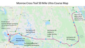
Monroe Cross Trail 50 Mile:
Male: Brian Sharbono - 6:13:29
Female: Joanne Fisher - 8:11:41
The Monroe Cross Trail 50 Miler is a point-to-point along the beautiful paved multi-use trails in Volusia County, starting from Rotary Park (902 W Park Ave) in Edgewater Florida and running 50 miles to the finish line at Central 28 Beer Company in DeBary, Florida.

Across Florida 200:
Male: Jerome Bareth - 63:52:00
Female: Lovelyn Findley - 76:37:32
The Across Florida 200-mile Endurance Trail Run across the State of Florida.
Male: Jerome Bareth - 63:52:00
Female: Lovelyn Findley - 76:37:32
The Across Florida 200-mile Endurance Trail Run across the State of Florida.

Pinellas Trail Challenge:
Male: Marc Burget - 5:59:51
Female: Jennie Eftikides - 6:53:40
The Pinellas Trail Challenge is a Ultramarathon that runs the Pinellas trail. The race is an out and back event that starts in St. Petersburg, Florida runs to Tarpon Springs and then back to Dunedin. The length of the race is measured at just over 46 miles.
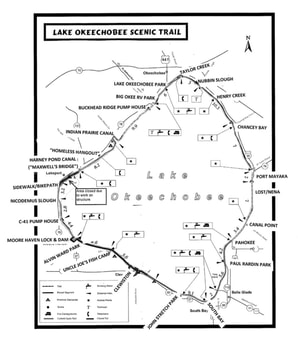
LOST 118:
Male: Chris Petit - 19:10:05
Female: Jamie Rotar - 18:36:15
The LOST 118 is a 118-mile full loop. The race is held during the full moon weekend each February and is run along the Lake Okeechobee Scenic Trail "LOST” surrounding Lake Okeechobee.
Male: Chris Petit - 19:10:05
Female: Jamie Rotar - 18:36:15
The LOST 118 is a 118-mile full loop. The race is held during the full moon weekend each February and is run along the Lake Okeechobee Scenic Trail "LOST” surrounding Lake Okeechobee.
